A photo a day for the last week of June

Jun_25_17

(6/25/17) Stained glass above doors at the old Veterans Home in Minneapolis.

Version 2

(6/26/17) We have a hummingbird! The new feeder is a success.

Jun_27_17

(6/27/17) Late afternoon soccer practice at the little park down the block by Minnehaha Creek.

Jun_28_17

(6/28/17) Minneapolis

Version 2

(6/28/17) Lake Nokomis, Minneapolis

Jun_30_17

(6/29/17) Otto’s favorite spectator sport

Version 2

(7/1/17) 2nd hole, Keller Golf Course, St. Paul. One of the great features of the remodeled course is the abundance of wild flowers and prairie grass.

. . . the behinder I get: 2 more weeks of a photo-a-day

Seems like more digging doesn’t get you out of the hole (!?!), but here are two more weeks of my photo a day project, including part 2 of our Arizona trip last month.

WEEK # 16

Version 2

(4/16/17) Easter Sunday morning hike in South Mountain Park, Phoenix. Ocotillo (“buggy whip cactus”) in bloom, with downtown Phoenix in the background. This beautiful park is a quick way to get out of town, do some mountain hiking, and see an undisturbed part of the Sonoran Desert. And this is a CITY Park!!!

Apr_17_17

(4/17/17)  Staghorn Cholla cactus in bloom in the eastern section of Saguaro National Monument near Tucson

Apr_18_17

(4/18/17) This room, now part of a store that sells art, dates back to the 1770s.  It’s in a preserved section of downtown Tucson that was once the Spanish-built Presidio de San Augustín del Tucson. In this photo, the original adobe walls, a strip of wallpaper, and the ceiling made of Saguaro Cactus ribs are visible.

Version 2

(4/19/17) A climber dangles above the road that winds its way to the top of Mt. Lemmon, northeast of Tucson.  The 30-mile drive up from the desert floor passes through climate zones that represent the geographical equivalent of a trip from Mexico to Canada. As you near the 9,159 summit, you’re surrounded by tall Ponderosa Pines and air temperatures that are usually about 30 degrees cooler than the city of Tucson below. It’s amazing that winter skiing is possible this far south.

Version 3

(4/20/17)  Surprises while traveling are often good, but this morning’s email was not one of them.  Our friend John Doom’s wife Ghislaine wrote to us that he was in the hospital in Flagstaff, having just been diagnosed with a nasty cancer in his back.  He was awaiting surgery this afternoon to install some metal rods to support vertebrae that had been compromised. We had planned to return our rental car in Phoenix today, but decided to drive from Tucson to Flagstaff to see him, to be with Ghislaine during the surgery, take her to their home in Sedona for the night and return her to the hospital in the morning.  In this photo, John gives us a little of his trademark wackiness and positive spirit as he prepared to go under the knife. John’s 4-hour surgery went well, and he is now receiving radiation treatment.

Apr_21-17

(4/21/17) Apache Junction, Arizona at sunset. Karen’s dad (in blue shirt) prepares to leave his winter home and head back to Minnesota.

Version 2

(4/22/17) Amarillo en Arizona


WEEK #17

Apr_23_17

(4/23/17) Omer takes the wheel for the first leg of the trip home, from Apache Jct. to Payson.

Apr_25_17

(4/25/17) Back home, back yard in bloom.

Apr_26_17

(4/26/17) The Happy Hour group ventured downtown this week, so here’s a view of the under-construction Nicollet Mall in Minneapolis. The Mall is being completely redesigned and revamped for the first time since in was built in the ’60s.

Apr_27_17

(4/27/17) The kids are back!

Apr_28_17

(4/28/17) OUTLOUD! a subgroup of the Twin Cities Gay Men’s Chorus did a song and dance parody of ONE! at this year’s MinnRoast, which is MinnPost’s annual fund-raising variety show at the Historic State Theatre in downtown Minneapolis. I got such a close-up view because I’ve been lucky enough to be asked to shoot video of this event for the past five years.

Apr_29_17

(4/29/17) We moved in to our house when this tree was blooming last year. Now, here it is again, right on schedule — one year to the day of closing and starting to move in. Happy anniversary, tree!

Catching up from a trip to Arizona

The past month has been kind of a blur. But it reminds me of why I like to take pictures. After a two-week trip to Arizona, we came back to yard word and the usual list of catch-up things to do. When I finally sat down this morning to look at the photos from the trip, I realized how important it is for me to have some sort of reminder of each day, a visual cue to trigger other memories of people and places we visited.

So, while I haven’t posted photos since April 8, I’ve been shooting every day.  Now I’m going to “post-post” photos, a week’s worth at a time, until I get up to date.

apr_9_17

(4/9/17) The trees were leafing out, the golf courses had been open for a month, and spring was in the air a couple of days before we left for Arizona. This was definitely not going to be a get-away from wintery weather.

Version 2

(4/10/17) Happy birthday to Karen on a rainy evening.

Apr_11_17

(4/11/17) After flying to Phoenix, we picked up a rental car and headed north.  Holbrook, AZ is on old Route 66. The newer chain motels and chain restaurants are on the other side of I-40, and the older businesses try to survive by playing up the kitsch and schlock (and spirit) of a bygone era.

Version 2

(4/12/17)  This guy was galloping south on U.S. 191 in the Navajo Nation near Ganado as we were going north. I really wanted a photo, so I turn the car around and drove past him a ways and stopped to wait for him to ride by.  He saw me hanging out the car window with my camera and gave me a big smile and wave. I don’t know your name, sir, but “Baa ahééh nisin, díidí” (translation: “about this, I feel grateful”).

Version 2

(4/14/17) Canyon de Chelly is one of the most under-visited of our National Parks and Monuments and one of my favorite places I’ve ever been.  It’s located in the Navajo Nation in northeastern Arizona, and probably shows more respect to the native people that any other national park.  In fact, it’s the only unit of the National Park Service that is entirely owned and operated by a Native American nation. The “White House” trail is the only place where non-residents can hike into the canyon without a Navajo guide.  The trail zigzags down the steep walls of the canyon and then follows the river to the “White House Ruins”, an abandoned ancient cliff dwelling that lies below a dizzying, overhanging, 800-ft shear cliff.

Apr_13_17

(4/13/17) Spider Rock is a famous formation in Canyon de Chelly and is a historic and sacred place for the Navajo people. It’s a magnificent spot to watch the early evening light soak the canyon floor as the sun goes down behind you.

Version 2

(4/15/17) Elgean Joshevama, Jr. is a full-blooded Hopi from the village of Lower Moenkopi, whom I met on the street in Flagstaff.  I bought this Kachina that he had carved.  He thanked me and said he was going to buy breakfast for himself and his friend. He’s a very nice man and he makes beautiful art.

Two great theaters in one week

We saw two great shows (a play and a movie) at two very different Minneapolis theaters last week —King Lear at the Guthrie and Manchester by the Sea at the Riverview.

Minneapolis and St. Paul are known as a good cities for live theater, for several reasons. There are many smaller companies around town that have managed to thrive (or at least survive), and several renovated classic old theater buildings that bring in Broadway shows and such. But the Guthrie is the big daddy – it has the name, the reputation, and the history. While some may not like the relatively new (10 years) home as much as the old one, and while some may have other reasons for staying away, the Guthrie Theater continues to be a regional — and national — force in the theater world.

Guthrie_2006

The (new) Guthrie Theater had just been built when I shot this photo (June, 2006) from under the Stone Arch Bridge. It was designed by architect Jean Nouvel to make the most of (and fit into) an industrial site amid the old flour mills on the Mississippi River in downtown Minneapolis. You can see its big, blue, protruding observation deck jutting toward the river.

This was my first King Lear, and I was enthralled by the whole production. (and the less-than-half-priced rush line tickets in the 6th row didn’t hurt.) It was a wonderful night, with the Guthrie doing what it does best.

An article in today’s paper says that attendance at the Guthrie is up this year, under the leadership of new artistic Director Joseph Haj.  But on Thursday evening, there were plenty of seats available.  So join the “Rush Club”, go on a week night, and get good seats at a deep discount.

IMG_8472 (1)

A bar at the Guthrie is dramatically lit — and gives a terrific views of the Mississippi River. The ghost-like projected figures of playwrights show up in unexpected places all around.

On the other hand, the Twin Cities have not been so kind to our movie theaters. St. Paul only has two operating movie houses within its city limits, and Minneapolis only has a handful. But one of them is a gem, and fortunately, not too far from home for us.

IMG_8235

Planning for the Riverview started a decade earlier than its late-1948 opening, but construction was delayed by WWII.


The Riverview Theater is a mid-century modern beauty that has managed to stay open for nearly 7 decades in a quiet neighborhood at the corner of 38th St. and 42nd Ave. South in Minneapolis. Just as with every American city, there used to be many neighborhood movie theaters, but most are gone now.

Any baby-boomer who walks through the Riverview’s lobby will feel nostalgic.  The colors, the furniture, lights, shapes, lines all remind us of what the world looked like when we were kids.

How do they do it, you ask? How have they survived when so many have failed?  A loyal following of regulars, yes.  An attention to preserving the mood and style of the time, yes. But here’s an idea for a business model for you:

  1. Show 3 or 4 different movies each day (one screening each) — some big names, some lesser known films or indies.
  2. Charge a small amount per ticket ($3.00 . . . and $2.00 for seniors!!!!!!!) and get very large crowds who buy lots of not-overpriced popcorn and other stuff. This place has a lot of seats, and they often fill most of them.

It’s one of those “so crazy it just might work” kind of plans. And it does work.

IMG_8227

IMG_8218IMG_8205

*****************************************

So, with two memorable theater experiences, a visit from the grandkids, and 5 more weekdays of being old enough to not have to go to work, life was pretty good last week. Continuing my Photo-a-Day project (for 10 weeks now), here’s a snapshot from each day of the week.

Version 2

(3/5/17) Fun with static electricity

Mar_6_17

(3/6/17) Apparently we’re not in a drought this spring, even with the lack of snow. Lake Nokomis is overflowing its banks in some places, making for some unexpected reflections (and wet shoes).

Mar_7_17

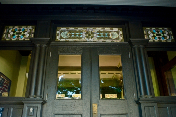
(3/7/17) One more picture from the Riverview Theater.  Have you ever seen a cooler entrance to theater bathrooms?

Mar_8_17

(3/8/17) Karen made these colorful ladies quite a few years ago out of scrap materials from re-siding her house. They used to be the “Swamp Girls”, living in the wetland behind her back yard.  When she sold the house two years ago, we moved to a rental house and because she wasn’t sure where we’d eventually land, she gave them to her friend Judy.  When we bought this house last spring, Judy thought they would look great in our back yard — and she was right. They are, from left to right – Kayci, Karen, and Karen’s Mom, each one holding a birdhouse or bird feeder.

Mar_9_17

(3/9/17) The windows in the Guthrie Theater’s bridge to nowhere provide some interesting views. Glass enclosures around the openings give funhouse-style looks at the surrounding area. The upside down sign is the iconic “Gold Metal Flour” sign from the top of the grain elevator.

Mar_10_17

(3/10/17) My neighborhood coffee shop, “Sovereign Grounds”.

Version 2

(3/11/17) Minnehaha Creek, downstream from the falls.

On Boston and a couple of old shirts

A week ago today, without even thinking, I put on an old grey sweatshirt I’ve had since 1996 but have probably not worn for several years. It wasn’t until after hearing about the horror in Boston last Monday that I thought about the shirt I’d worn the night before. It was an inexpensive sweatshirt with the word “BOSTON” printed on it that I’d bought it as a souvenir of my trip to run the Boston Marathon 17 years ago. I got a chill when I realized I hadn’t even remembered that it was marathon weekend until I heard about the bombings the next afternoon.

Yesterday I wore a Twin Cities Marathon shirt to the health club, as I often do. A woman walking by me said, “good to see you guys wearing your shirts”. I looked around and two other people near me had marathon shirts on, too — but they were from other races. I wondered why a stranger would say she was glad to see the shirts. As I watched some of the endless reports about the tragedy on the TV screens while running on the treadmill, it dawned on me that she might have been referring to our shirts as a sign of support for the people at the Boston race.

As I chugged away on the treadmill — 17 years older, 20 pounds heavier and a LOT slower — memories of my big race day flooded back to me. I thought about the bus ride to the little town of Hopkinton, part of the enormous field of runners (almost 40,000) who ran that year to commemorate the 100th anniversary of this unique and historic event. I remembered the exhilaration of the start and the energy created by the river of thousands of runners flowing through the countryside and small towns on the first part of the course. I could picture the huge billboards with old black and white photos from the early races. But most of all, I remember the people, the spectators, all along the course. They were there to cheer on the runners, to be sure, but really they were there to cheer for the community — to cheer for themselves and for each other. There were bands, there were Patriots Day parties, there were kids up in trees, there were people wearing (and painted in) red, white and blue all along the way. All were cheerful, all were proud and all were glad to be part of this American spectacle.

I think an urban marathon is a community event in ways that no other sporting event can match. It’s about so much more than just the athletes. Think about it — you can walk up to the course at any point and (free of charge) literally touch everyone from a world-class runner down to a plodding 6-hour jogger. The race cuts right through neighborhoods and downtown streets — no need to drive to a suburban stadium or buy an expensive ticket at a downtown arena.

Over the past week, the people of Boston have shown what they’re made of. They’ve shown the rest of us how to handle unthinkable tragedy — just like New Town has recently, just like New York City did in 2001, just like Oklahoma City before that, and just like other communities who have suffered severe trauma. None of us know for sure how we will react when and if it’s our turn, but this week we can take strength from watching and listening to the people of Boston. Because they are strong and resilient — even defiant — we believe that we can be, too.

The bombers chose a big event, an important event, an event with easy access, to spread their particular brand of terror. What they didn’t realize is that they chose an event in a city that will not shrink in fear and ultimately will be stronger, not weaker because of their actions. My deepest sympathy to those directly affected last Monday and my thanks to the people of Boston for what you’ve taught us.

I’m wearing my BOSTON sweatshirt as I type this and I’m going to be wearing it a lot for a while. It’s an honor to have had the chance to be a miniscule part of the history of this great event and great city.

DSC_1687

Some day I’ll get back to blogging again

Back in September, I got a wonderful opportunity to do a weekly photo-based “blog” for MinnPost called View Finder. It’s been great for me. I love taking pictures and giving myself little assignments. Some weeks have been easier than others. Some groups of photos have been better than others, but I like the experience and the opportunity to show my photos. But that project has been kind of draining my blogging energy.

I miss writing about stuff. When I started this blog almost two years ago, I didn’t realize that I would enjoy writing or be any good at it. Writing about whatever interested me — coupled with a few photos — made me more thoughtful and forced me to take time to organize and package my thinking. I’ve gotten away from that. I need to get back to it soon — not because anyone else needs to read it, but because I need to write it.

My last two blog posts have basically been promotions for my first 10 MinnPost View Finders. I’ve now done 18 weeks of it. So continuing my tradition of self aggrandizement, here are my 8 most recent View Finders with links to the MinnPost page where they are found. You can also find all my View Finders on my personal archive page on my See to Sea Productions website.

I hope that I’ll soon have something else to say.


Almost Winter on the North Shore
December 1, 2011

.

.

.

Starbase Minnesota
December 8, 2011

.

.

.

.
Local filmmaker making a documentary about light rail construction
December 15, 2011

.

.

.
North Mississippi Regional Park is an undiscovered urban gem
December 23, 2011

.

.

.

Como Park in the winter
January 5, 2012

.

.

.

Warm Minnesota winter
January 12, 2012

.

.

.

Martin Luther King Day events in the Twin Cities
January 19, 2012

.

.

.

U.S. Pond Hockey Championships in Minneapolis
January 26, 2012

5 More views found

This is another blog post about the other blog posts I’ve been doing for MinnPost, called “ViewFinder”. Maybe it’s a little like looking into the mirror at the barbershop that is reflecting the mirror on the opposite wall, where you see yourself repeated in diminishing size off into infinity. But I like showing the various things I’m working on in different ways to different audiences. Call it shameless cross-self-promotion if you wish.

I’ve done the weekly ViewFinder blog for 10 weeks. It’s a photo-driven entity, but I do some writing as well, mainly to introduce the photos. In my newest post, which is running in MinnPost today, I’ve also added a short video.

Here are links to my 5 most recent ViewFinder posts. If you’d like an easy way to find the first 5 I did, you can go to my previous post on this site.

The Big Gay Race
October 20, 2011

OccupyMN Wake for the Middle Class
October 27, 2011

Dia de los Muertos (Day of the Dead)
November 3, 2011

Big Water Film Festival
November 10, 2011

Lustron Houses on Nicollet Avenue in Minneapolis
November 17, 2011

Finding a view

A couple of months ago, the editors at MinnPost asked me if I’d be interested in doing a weekly blog for them. They suggested a photo-based format that would feature a variety of subjects from week to week — events, places, people — anything that I find visually interesting. I thought about it . . . for about a second . . . and then jumped at the chance. It was a generous offer and an amazing opportunity to let me give myself a weekly photo assignment and have a forum for sharing it.

This week I posted my fifth “View Finder” piece, a group of pictures about the section of the Mississippi River that flows between Minneapolis and St. Paul south of St. Anthony Falls. The fall colors had peaked and were beginning to fade.

Here are my first 5 View Finder posts. Just click the blue link to go to the MinnPost page.

Monarch Butterfly Festival at Lake Nokomis
September 15, 2011

My love affair with Keller Golf Course
September 22, 2011

Revisiting Highway 61
September 29. 2011

Twin Cities Marathon
October 7, 2011

Exploring the Mississippi River Gorge
October 13, 2011

Coalwood is in my heart today

Life has its turning points. The little town of Coalwood, West Virginia represents a big one for me. It was after visiting the October Sky Festival there in 2005 that I decided to make a documentary film about the town. Who knows why. I had no experience as a filmmaker, no camera, no concept of all that it takes to video a video production of that scale.

In October of 2009, after a half-dozen more trips to Coalwood and four years of learning a few skills, a dream came true as I was able to go back to Coalwood and hand-deliver a DVD of “Welcome to Coalwood” to each of the people who had appeared in the film or helped me make it and personally thank them for welcoming me into their homes and letting me into their lives.

That 2009 trip was emotional for me, as some of the people were getting on in years and others had experienced major life changes. I’ll never forget the heartfelt thanks and hugs I received from these wonderful people just because I took an interest in them and their little town. It didn’t matter to them that the film wasn’t the highest-quality production or that it was made by a beginner.

Homer Hickam had put Coalwood on the map a decade earlier with his wonderful memoir, Rocket Boys, which was made into the movie October Sky. My project covered some of the same ground, but in a different way — by finding people from the old days who were still around to tell the history of the town as they remembered it.

My biggest initial motivation for attempting to make the film was to preserve on video some of the older people that I’d met. In fact, when I drove down there with my daughter Emily in the summer of 2006 to do my first shooting, I really didn’t know what I was doing — but I felt a sense of urgency to record some of them before it was too late.

Red Carroll (2006)

I’m glad I did. Since I’ve made the film, several wonderful Coalwood residents who were “stars” in my film, including Red Carroll, Gene Turpin and Fred Beavers have died. Katie Jones has since move away, as has Janice McClure.

Eugene Turpin (2006)

"Miss Katie" Jones and Emily Date (2006)

Bill & Reba Bolt / Jim and Carol DeHaven (2006)

The Company Store, one of the two most import existing buildings in town, was torn down just as I was finishing the film, dealing a crushing blow to any historic preservation effort.

It’s really hard to explain to some people why that little, falling-down town grabbed me, but the fact is, it did. I’ve given up trying to explain it. It’s like trying to explain why you fell in love.

I’m a big believer in the importance of place. We all have places that we are emotionally connected to. For most of us those places are not famous or well-known, but they have meaning to us and represent something deeply important in our lives.

Coalwood is one of my special places. It changed my life.

The October Sky Festival is today. I should be there and regret that I’m not.

To the people of Coalwood: I’ll be thinking about you all day today. Thank you for what you’ve given me.

I’ve missed two October Sky Festivals in a row. I can only hope that there will be another one next year.

Red Carroll talks with a group of Minneapolis teachers on the steps of the Clubhouse (Oct 2008)

If you’d like to see some of my other Coalwood-related posts, here are the links:

Big Creek High School: A missed opportunity for historic preservation

Coalwood on my Mind

Memories of Red Carroll

“Owe my soul to the company store” — some like it that way.

Great bike rides of the Twin Cities that begin and end at my house #2: The Grand Rounds

(Note: To see my first “great bike rides” post from about a year ago, go here)

I used to think “The Grand Rounds” was a rather pretentious name added in modern times to the more than 125-year old string of parkways that wind through the city of Minneapolis. But I recently learned that the term dates back to 1891, when William Watts Folwell used it to describe landscape architect Horace Cleveland’s masterful proposal made to the newly-formed Minneapolis Board of Park Commissioners 8 years earlier. Now that I know the name is that old, I like it.

Horace Cleveland as a young man. He was nearly 70 when he submitted his design for the Grand Rounds !

Minneapolis has one of the best urban park systems in the world. We would have none of it today but for the vision, forethought, and actions of an amazing string of parks commissioners (along with Cleveland’s detailed plans) in the late 19th and early 20th century, including Charles Loring, William Berry and Theodore Wirth.

I’ve biked most of this route many times, but never as a whole. So a couple of days ago, I decided it was time to grab my camera and saddle up. I’d seen different numbers for the total mileage — usually 50-53 miles, but I also knew that included some dead-end spurs. I decided to just do the main, basic route and see how it works as a loop.

Cleveland’s idea was to tie together some of the most beautiful parts of the city in such a way that you could make the whole trip without ever leaving a park-like setting. For the most part, it does that very well. The Minneapolis chain of lakes, along with the Mississippi River and Minnehaha Creek, are well-known treasures, but the ride also includes some impressive boulevards in the city’s northern areas. Most of the route is, indeed, “grand”, but there’s a short “missing link” of about 3 miles in the northeastern part of the ride that isn’t terribly scenic. Many plans have been proposed over the years to finish it, but so far it’s still missing. A variety of street options traverse the gap and get you downtown to join up with the river.

The dark blue line shows the Grand Rounds. Note the dotted lines through an industrial and residential part of northeast Minneapolis. The outline of the city limits can be seen where the shade of green changes.

Since I live a couple of block from Minnehaha Creek, I bike and run the southern part of the Grand Rounds a lot, but the beauty of the creek and the lakes never gets old. A quick loop around the lakes or a run around Lake Harriet never fails to lift my spirits.

My grand tour the other day ended up totaling about 37 miles. As I said, there are other ways to do it that add more mileage. The route also intersects with a lot of other bike paths on which you could wander all day. It’s a great city for biking.

Here are a bunch of photos from my trip. Along the way, I somehow lost my little notebook that I was writing the mileage in at photo stops (imagine me losing something), so the mile numbers are from “Map My Ride” and are approximate — also, of course, pretty meaningless unless you start at my house. But if you ever do want to start at my house, give me a call and I’ll go with you. It’s a great urban ride.

0.7 - We drop down into the Minnehaha Creek valley to get started.


1.5 - First look at good old Lake Harriet.


5.5 - Cedar Lake's south beach


6.7 - North side of Cedar Lake. The railroad and the Cedar Lake Trail (not ours) head toward downtown Minneapolis.


6.8 - on the other side of the railroad bridge is tiny Brownie Lake, an often overlooked little gem.


8.3 - Theodore Wirth Golf course. What a view!


8.8 - Statues depicting Theodore Wirth (Minneapolis Parks Commissioner in the early 1900s) with some kids for whom he helped provide a beautiful place to play, are near clubhouse of the golf course that bears his name.


10.7 - Victory Memorial Drive honors those who died in WWI


15.2 - Downtown skyline over the rail yards of "Nordeast".


16.2 - Another peak at downtown from the 10th hole at Columbia Park, another very nice municipal golf course.


17.3 - Quiet, residential neighborhood on St. Anthony Parkway with happy, safe, above-average kids.


20.8 - After a trip through the "missing link", we're downtown.


21.3 - Almost everything you need to know about Minneapolis is represented in this photo -- flour mills, St. Anthony Falls, Mississippi River, hydroelectric plant, barge going through lock & dam, James J. Hill's stone arch railroad bridge. This area is ground zero for Minneapolis .


21.5 - New I-35W bridges show no trace of the terrible tragedy that happened here 4 years ago.


23.2 - Back to green and blue landscape. The Mississippi River from West River Road across from the University of Minnesota.


28.0 - Minnehaha Falls


29.3 - The path hugs Minnehaha Creek


30.2 - Lake Hiawatha


32.0 - Lake Nokomis -
About five more miles and we're home - around the lake and up the Parkway.